California may be known as the car-culture capital of the country, but Arizona boasts some of the most scenic, historic and fun roads (without the traffic). Here’s a look at six of our favorites.
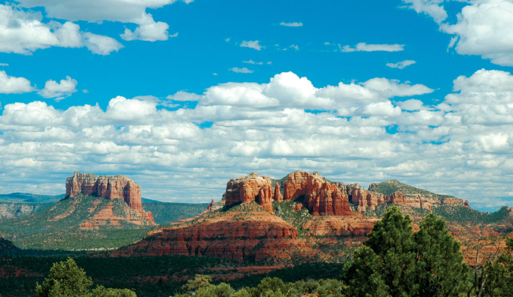
Red Rock Loop Road
Distance from the ‘Y in Sedona (one way): 13 miles Attractions: Crescent Moon Ranch, Red Rock State Park, views
Does driving aid in digestion? Maybe. All we know is that we love going for a drive after an early dinner, and Red Rock Loop Road offers some beautiful views in a very short distance. The views are even lovelier at sunset when the red rocks turn a fiery orange.
From the ‘Y, head south on State Route 89A for four miles until you reach Upper Red Rock Loop Road. Turn left. You’ll quickly pass Sedona Red Rock High School before the road narrows and descends in a series of sharp (and oh-so-fun) switchbacks. The views begin almost immediately: Cathedral Rock and Courthouse Butte both rise from the valley floor below the road. Schuerman Mountain stands tall outside your passenger window. At miles 4.8 and 5.4, you have the chance to pull over to the left of the road, park on dirt aprons and get out from behind the steering wheel to take a few photos. Red Rock Loop Road levels out after six miles at its intersection with Chavez Ranch Road. We highly recommend you turn left on Chavez Ranch and then right on FR 216A to Crescent Moon Ranch or, as it’s more commonly called, Red Rock Crossing. The recreation area offers some of the most recognizable and stunning views of Cathedral Rock and Oak Creek. Take a short walk along Oak Creek, where the views only get better. The creek-side trail ends at Buddha Beach, which boasts a popular swimming hole and rocks stacked by visitors. Crescent Moon Ranch is open from 9 a.m. to 8 p.m. daily. Admission is $10 per vehicle. Drive back to Red Rock Loop Road and make a left. You’re now driving through a residential area, so please drive cautiously and be mindful of homeowners. After driving nine miles, the pavement ends, and you’re navigating a dirt road (fine for cars). The pavement begins again at mile 9.8. Ten miles into your drive, the entrance to Red Rock State Park will be on your left. At press time, the state park was scheduled to close its gates June 3; however, local activists were raising money to keep it open. If they succeed, stop at the educational park for more photo opportunities and to explore the visitors center, which offers info on area fauna and flora. The park is open from 8 a.m. until 5 p.m. daily. Admission is $10 per vehicle. Continue on Red Rock Loop Road, and after 12 miles, slow down and look to your left at a rock outcropping. Near the top and underneath a ledge you’ll see an Indian ruin made from red rock. Another half-mile further and you’ll see FR 9853 on your right. The short, but rough, dirt road leads to the Red Rock Loop trailhead and a delightful two-mile hike. Thirteen miles from the ‘Y, Red Rock Loop Road meets up with SR 89A once again. Turn right and go back into town.
Oak Creek Canyon
Distance from the ‘Y in Sedona (one way): 15 miles Attractions: Grasshopper Point recreation area, Slide Rock State Park, campgrounds, picnic areas, seasonal waterfalls, Oak Creek, Midgley Bridge, Hoel’s Indian Shop, Oak Creek Vista
On Aug. 24, 1984, the Arizona Department of Transportation designated State Route 89A through Oak Creek Canyon the Sedona-Oak Creek Canyon Scenic Road. The drive from Uptown Sedona to the top of the Mogollon Rim just south of Flagstaff is one of the most popular tourist attractions in Red Rock Country, as anyone who has tried to get to Flagstaff from Sedona during peak season for an appointment can tell you.
Starting from the ‘Y, the mouth of Oak Creek Canyon begins after a short, half-mile drive through Uptown. You’ll traverse Midgley Bridge, which spans Wilson Canyon, after driving less than two miles. Within the next mile, you’ll pass Grasshopper Point, a popular swimming hole and picnic spot ($8 per car); Rainbow Trout Farm, which offers family fishing; and Indian Gardens where you’ll find a visitors center, a delish deli and general store, and Garland’s Indian Jewelry. Four-and-a-half miles into your drive, you’ll come upon a Dairy Queen on your right and a large parking lot where Native American vendors sell arts and crafts. Thus far, Oak Creek has been flowing below you – you’ll catch glimpses of its clear waters outside your passenger window. During the summer, green trees form a canopy over this section of the road. If you are looking for a great picnic spot, pull into Encinoso Picnic Area, which you’ll find five miles from the ‘Y on your left. The picnic spot is named after Encinoso Falls, a seasonal waterfall that cascades down the walls of Oak Creek Canyon on the opposite side of the road from the picnic area.