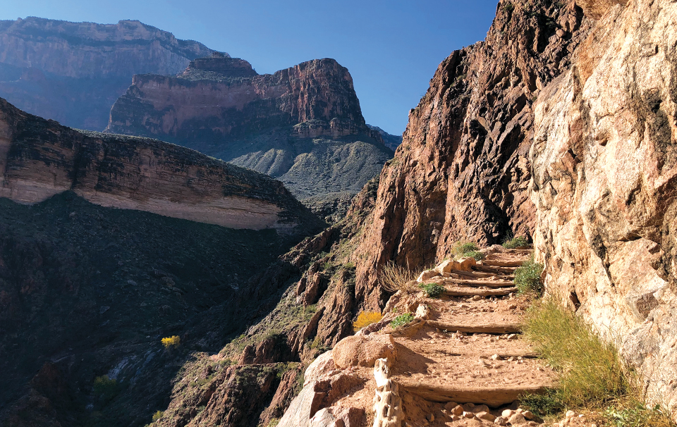
Bright Angel
Round-Trip Distance: 18.5 miles; At a Glance: Iconic, Stunning Arizona Views
Although not in Sedona, we couldn’t run this list without this Grand Canyon trail. It’s one of the most iconic hikes in the world. We love Bright Angel Trail for its changing ecological zones, gurgling streams, classic views and slightly more knee-friendly incline than the neighboring South Kaibab Trail. Depending on the season, Garden Creek provides small waterfalls and a pleasant soundtrack to your journey. The trail traverses slickrock shelves, narrow ravines and a series of switchbacks called the Devil’s Corkscrew (not nearly as intimidating as it sounds). Indian Gardens, complete with campground, ranger station, restrooms, water and picnic tables, is the halfway point along the trail. For the fit hiker, it’s possible to hike to and from Indian Gardens in a single day, but we would never recommend a round-trip journey to the Colorado River at the bottom of the Grand Canyon as a day hike. To tackle the entire Bright Angel Trail, secure a backpacking permit by visiting nps.gov/grca and start training.
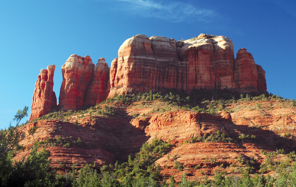
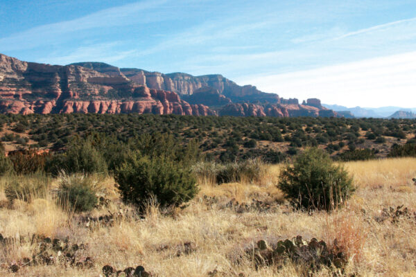
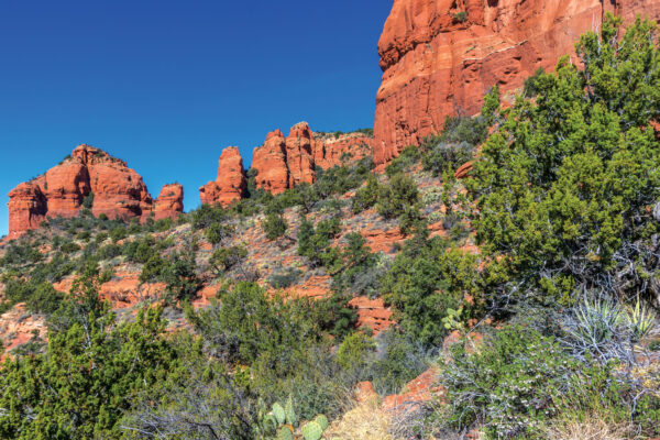
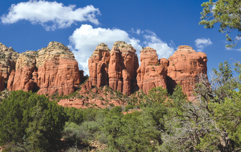
Cathedral Rock
Round-Trip Distance: 1.7 miles; At a Glance: Short, Steep Climb, Classic Sedona Views
Even seasoned hikers have to admit that hiking to the saddle of Cathedral Rock isn’t a walk in the park, but its short distance makes it completely doable. And the views you’ll encounter at the saddle are bar none. The trail begins climbing as soon as you leave the parking lot. Be prepared to climb, shimmy and wiggle through cracks and crevices in your quest for the saddle. The views improve as you tackle this tough trail – your reward for trying. You’ll spy iconic red rock formations including Courthouse Butte, Bell Rock, the Chapel of the Holy Cross, Lee Mountain and the Rabbit Ears. Once you reach the saddle, you’ll see Oak Creek far below and Mingus Mountain and the town of Jerome in the distance. Be sure to spend time savoring the end of your hike by exploring the saddle and admiring these amazing Sedona vistas.
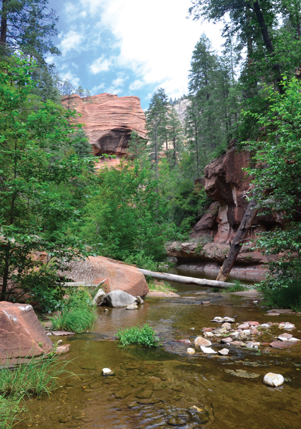
West Fork
Round-Trip Distance: Six miles; At a Glance: Classic Sedona Trail, Waterways
Although West Fork Trail in Oak Creek Canyon is most popular during the fall when the leaves change, it’s wonderful in any season. In the winter, a fresh blanket of white snow makes the trail even more magical. In the summer, you’ll want to take a dip to cool off. And even at six miles, the hike remains easy because there’s little elevation change – it’s nearly flat the entire route – though you will need to cross the creek via rocks and branches numerous times. The trail follows a tributary of Oak Creek. Gambel oaks, cottonwoods and maples provide plenty of shade. Though you won’t see any major red rock formations, you will see red rock cliffs and perhaps even more impressive, sky-high canyon walls. It’s possible to hike the trail for 14 miles one way, topping out on the Mogollon Rim, but that requires wading and swimming. But we’d suggest taking a relatively easy stroll, packing a picnic and soaking up the scenery all around you.
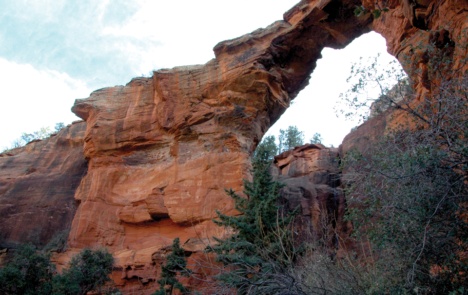
Devil’s Bridge
Round-Trip Distance: 2.6 miles; At a Glance: Easy Trail, Striking Sandstone Formation
In recent years, social media has made Devil’s Bridge – the largest sandstone arch in town – even more of a star than it already was. And it’s easy to see why so many love this hike. The views are fantastic, the hike is relatively easy, and the arch is quite the site in an area full of them. You’ll need a high-clearance vehicle to reach the trailhead. If you drive a compact car, it’s an easy 1.3 mile walk from a paved parking lot. You’ll reach a fork at 0.71 miles from the trailhead. Stay left here. Climb a staircase, admire the views of the Seven Canyons area and look for the bridge on your left. You can walk across the bridge. Although a sign will warn you about the instability of sandstone arches. Proceed at your own risk. Before you head out, walk down the staircase and turn right to get a killer view of the arch from its base. – Teresa K. Traverse
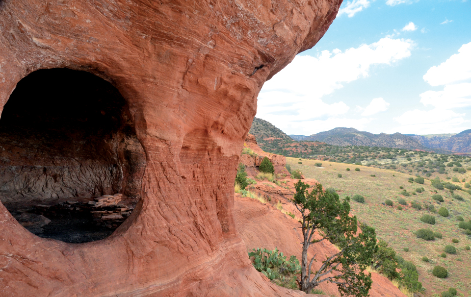
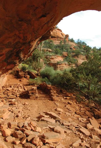
Robbers Roost
Round-Trip Distance: One mile to three miles depending on your vehicle; At a Glance: Moderate Trail, Stunning Views, Cave
If you have a four-wheel-drive vehicle, take a bumpy and dusty ride along Sedona’s backroads to Robbers Roost, a red butte visible from all over town. There you’ll find a cave with some interesting – though not necessarily Native American – ruins. If you don’t have a high-clearance vehicle, you’ll need to park along the road 1.5 miles from your destination. The trail leads you up and around the butte. If you’re afraid of heights – or if you’re not surefooted – this portion of the hike will make you nervous. To get into the cave and check out the ruins, you will need to climb over a retaining wall at the edge of the butte and drop into the ruins. Once inside, you’re treated to a near-perfect circular window in the red rock that frames an awe-inspiring view of Sedona. Local lore says outlaws used the cave’s window to keep a lookout for the sheriff’s posse, thus giving the butte its moniker. But today, we’ll just appreciate the awesome views.
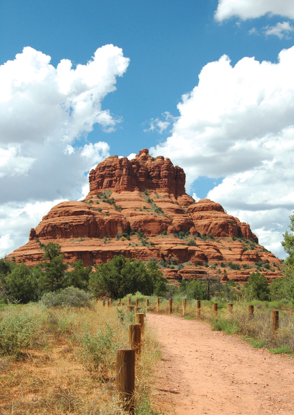
Courthouse Butte Loop
Round-Trip Distance: 4.5 miles; At a Glance: Moderate Trail, Extensive Red Rock Views
The Village of Oak Creek boasts some of the most recognizable rock formations in all of Sedona, and you get a glimpse of all of them along this easy-to-moderate loop hike. Be sure to pack a hat; there’s virtually no shade on the trail. Start hiking Bell Rock Pathway from the trailhead near Bell Rock Boulevard, and immediately you are treated to grandiose views of Castle Rock, Bell Rock and Courthouse Butte. Courthouse Butte Loop begins about a half-mile into your hike – look for the sign trail on the right. The loop circles Courthouse Butte and winds its way through chaparral, a slickrock wash that usually has puddles and ledges with stellar views of the Rabbit Ears formation. About halfway through your hike, the views extend beyond Courthouse Butte and Lee Mountain and stretch all the way to Capitol Butte, Cockscomb and even Robbers Roost. For a fun side hike with sweeping vistas, make the quick jaunt up Baby Bell, which you’ll find near the junction of Courthouse Butte Loop and Llama Trail. The loop eventually meets up with crowded Bell Rock Pathway again, and you’ll be dodging mountain bikers and hearing traffic from nearby SR-179, but it’s completely worth it.
Soldier Pass Arches
Round-Trip Distance: Three miles; At a Glance: Moderate Trail, Striking Arches
Many people are familiar with the Soldier Pass Trail, which takes you past local landmarks such as the Devils Kitchen sinkhole and the Seven Sacred Pools, but we prefer the Soldier Pass Arches hike. It’s a bit more technical than its parent trail, but the reward – three massive arches – is rich. Hike Soldier Pass Trail past the Wilderness Boundary, and after walking 1.3 miles, keep your eyes peeled for a side trail on your right. You won’t see the arches immediately, but the first one comes into view when you reach a red rock shelf. After the shelf, the trail becomes very steep and rocky, so watch your footing. The climb is short, and once you reach the base of the first arch, you feel like you are in a cave. (The arches are actually alcove roofs that have broken away from a mesa.) It takes some scrambling to get to the second and third arches, and we think the first one is best. From this arch, you have bird’s-eye views of the entire area, and even in the summer months, the alcove is cool and inviting.
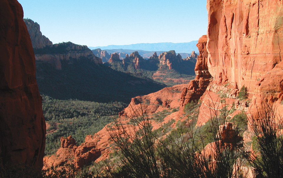
Mitten Ridge
Round-Trip Distance: Five miles; At a Glance: Moderate Trail, Sweeping Sedona Views
The views from the trails along Schnebly Hill Road are some of the finest in all of Red Rock Country. For the most bang for your buck, we recommend hiking to Mitten Ridge, a large butte that, when viewed from a distance, looks like a thunderbird stretching its wings. Start your hike on the Cowpies Trail, which is about four miles north on Schnebly Hill Road (you’ll need a high-clearance vehicle to drive the road). A half-mile into your hike, the trail splits. Stay straight and make your way toward the base of Mitten Ridge. To your left, you’ll see the aptly named Cowpies formation, and above you to your right, Merry Go Round Rock cheerfully stands. After hiking 1.5 miles, you’ll encounter views that extend across West Sedona and the Verde Valley. Follow the cairns that lead the way up to the ridge’s saddle. From the saddle – our favorite part of the trail – you can look down on Schnebly Hill on one side and Oak Creek Canyon on the other. The saddle is expansive, so plan to spend time wandering around and taking in the different vantage points.
Fay Canyon
Round-Trip Distance: Three miles; At a Glance: Easy Trail, Beautiful Scenery
Fay Canyon is one of the most popular hikes in Red Rock Country, so don’t head out on this journey expecting solitude. But it’s a popular hike for good reasons: There’s plenty of parking at the trailhead, the route is relatively flat, and the scenery along the way is awesome. Steep red rock walls rise up on either side of the trail, the sky is a narrow ribbon of blue, and you’ll find yourself hiking past tall spires and pinnacles mixed in with the juniper and pines. Don’t miss this one part: After hiking about 0.7 mile, take a side trail on your right and make the short – but steep and rocky – trek to Fay Canyon Arch. Even if you choose not to explore the arch up close, you can still see it from the main trail. The trail eventually meets the remains of a large rockslide. Climb up the boulders, and make your way along a slickrock ledge. Look behind you for picture-perfect views that include Courthouse Butte, Bell Rock and Cathedral Rock.
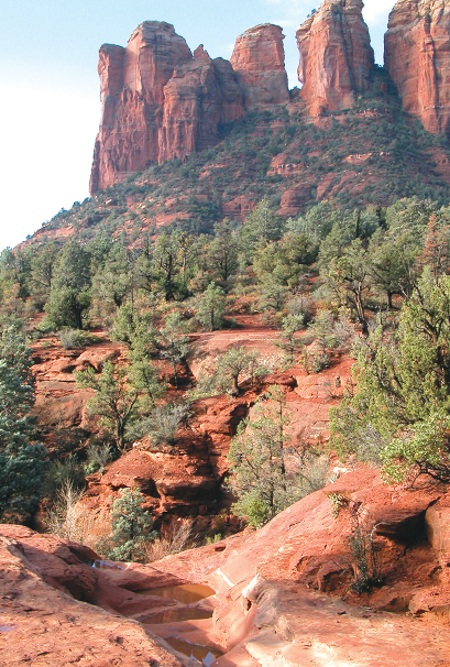
Coffee Pot Rock
Round-Trip Distance: Two miles; At a Glance: Easy Trail, Red Rock Vistas
Every now and then, we stumble upon a trail that surprises us, and the easy route that leads to the base of Coffee Pot Rock was one of those. It’s a perfect hike to share with out-of-town guests: It’s close to town, short and flat, and provides up-close views of the red rocks as well as wide-sweeping panoramas of our lovely little town. The hike begins at Sugarloaf Trailhead. Take the Teacup Trail and hike past the junctions of Sugarloaf Loop and Sugarloaf Summit. On your left, look for a large bush encircled by rocks. Turn here, and you’re on your way to Coffee Pot Rock. The trail is easy to spot, and the wide pathway gently makes its way to the base of Thunder Mountain and Teacup Rock. The trail ends under Coffee Pot’s “spout.” The flat, wide slickrock ledges in this area allow for plenty of time to sit and soak up the views of Airport Mesa, Cathedral Rock, Soldier Pass and a good portion of West Sedona.