HAILEY GOLICH
All photos by Hailey Golich. Visit haileygolich.com to see more of her work.
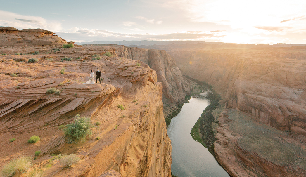
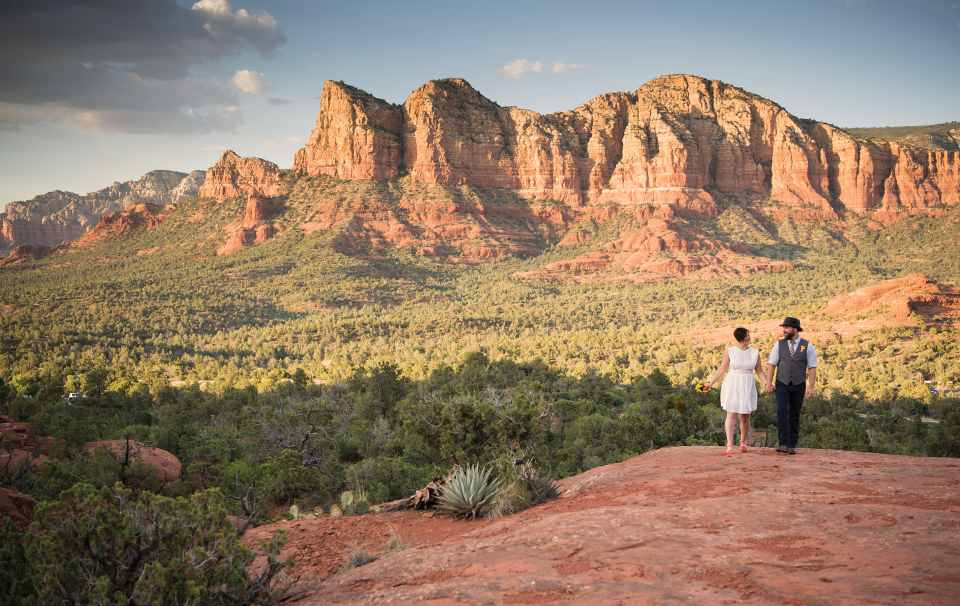
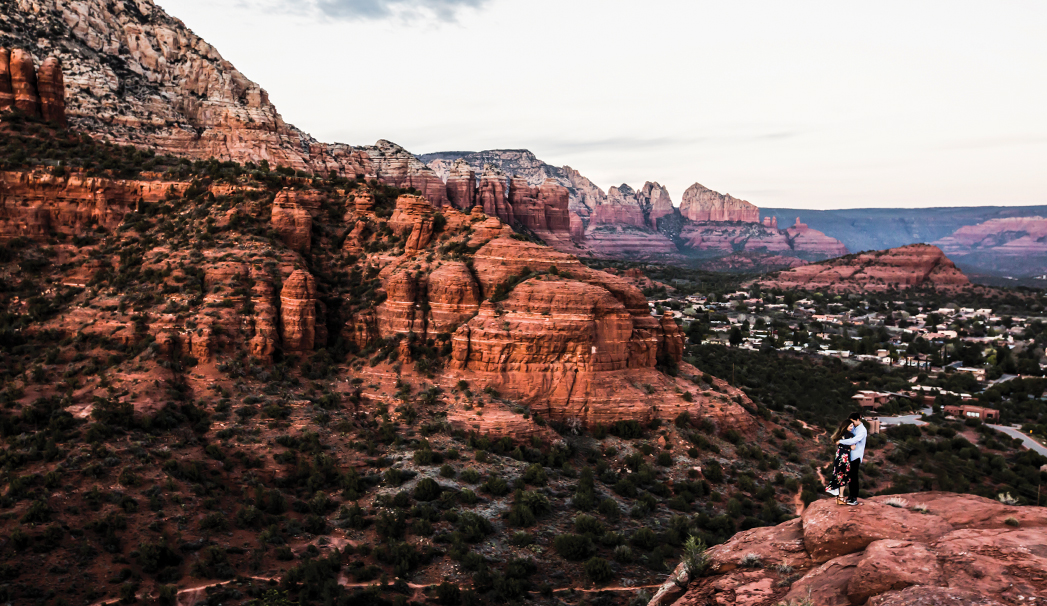
HORSESHOE BEND
You’ve probably seen thousands of images of Horseshoe Bend (it’s off to the right in the picture). But you’ve probably never seen one that looked quite like this. You can only get this photo if you book a private tour with Horseshoe Bend Slot Canyon Tours. The company will take you to this private overlook, which is just to the left of the public one. “If you try to do something like this over at the public overlook, you’ll probably never get a photo like this because there’s going to be hundreds of other people on the edge with you watching sunset. If I’m ever recommending something in that area, I always say, ‘Take the private tour, and go at sunset,’” says Hailey Golich.
What Makes This Spot So Photogenic: “Compositionally, I like how the river leads your eye to the photo. It also just shows the perspective of how small you are in this location. Sometimes you don’t really get that as much when Horseshoe Bend is in the background,” she says. “It’s really unlike any other place I’ve been before. I’ve traveled a ton. And there’s no other place in the world that looks like this.”
Photography Tips: “From a photographer’s point of view, having a wide angle lens is super important to get the whole expansive landscape in the photo. Which is maybe different than other locations you photograph. Definitely having a wide-angle lens, photographing at sunset, and taking the private tour, and you can’t go wrong,” says Hailey.
Directions: To get to this spot, you’ll need to book a private tour with Horseshoe Bend Slot Canyon Tours. The tour guides will take you out to this private viewing platform. The couple is standing on a ledge that’s off to the left.
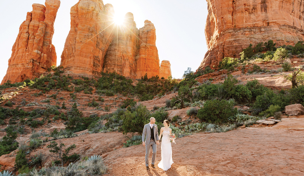
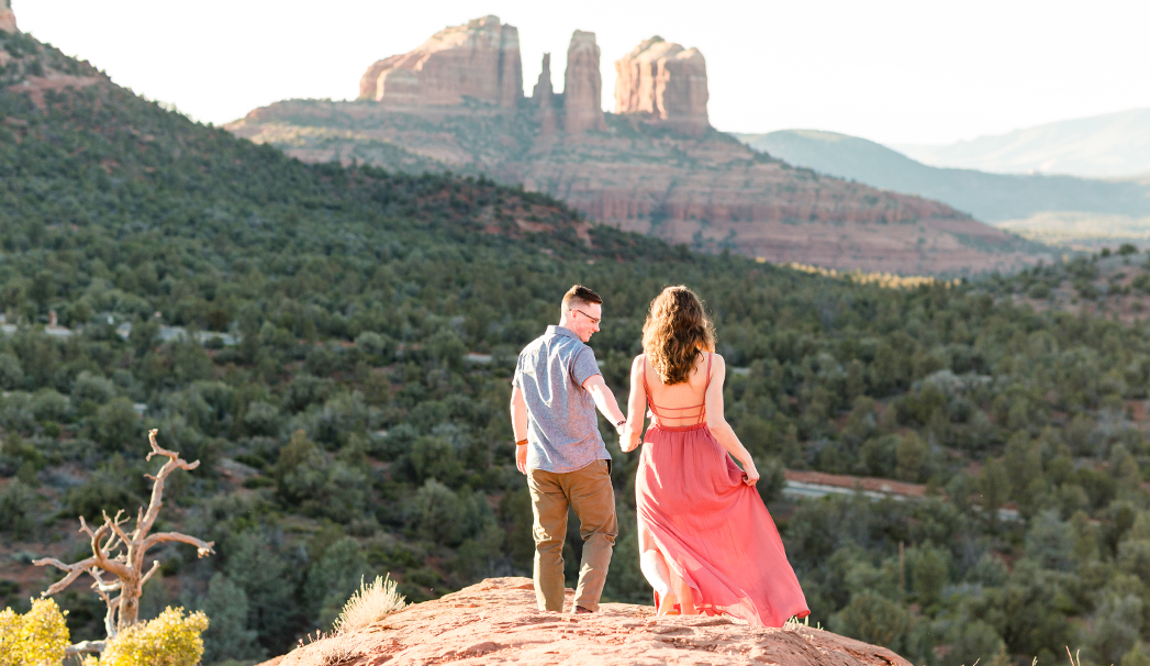
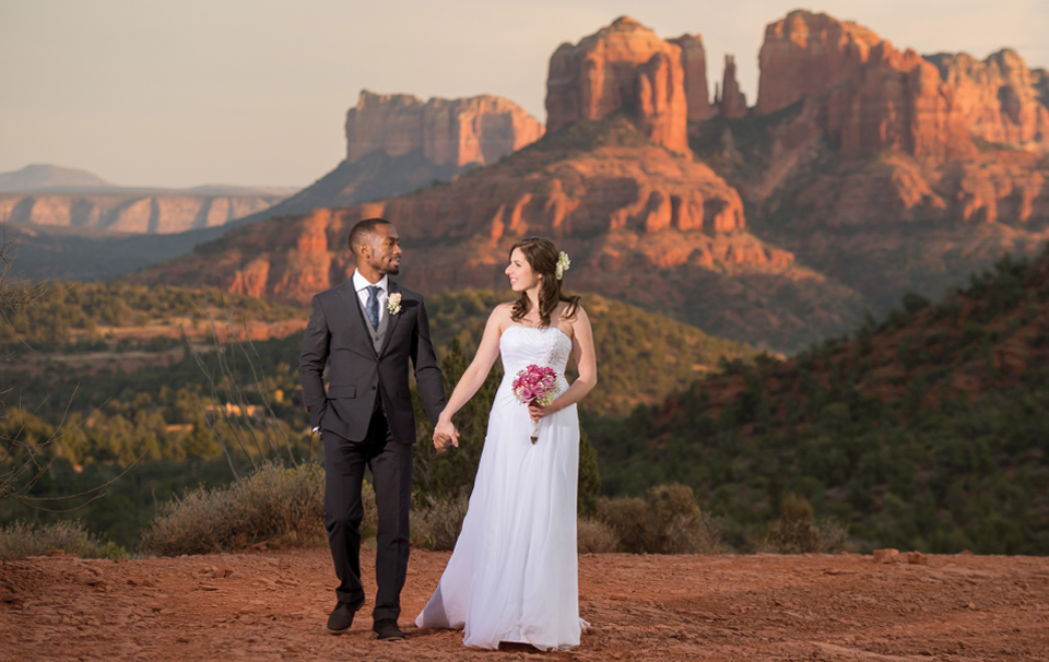
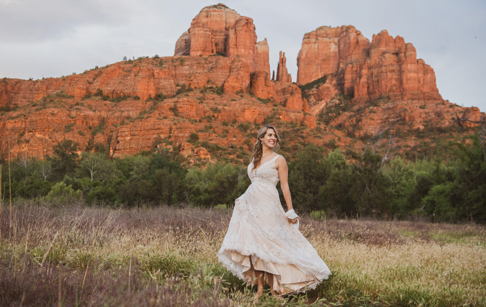
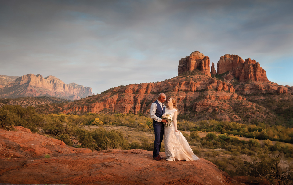
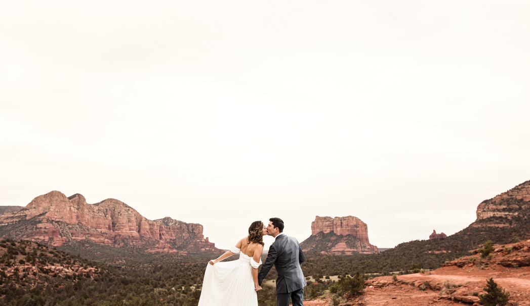
CATHEDRAL ROCK
You can find this view roughly two thirds from the Cathedral Rock trailhead, just to the right of the trail.
What Makes This Spot So Photogenic: “A lot of people are attracted to that spot because you have more of the prominent red rock in the background. You’re much closer to the red rocks versus a lot of the other places are more vista views,” says Hailey. “People really like Cathedral because you’re surrounded by these huge red rocks. And you can get up close to them.”
Directions: From Uptown Sedona head South on AZ-179 for about 3.7 miles. Turn right on Back O’Beyond Road. Drive about 0.7 mile and park. The parking lot is to the left of the road. You must purchase a Red Rock Pass to park here. Hailey estimates that this specific location is about two-thirds of the way up the trail. This spot will be to the right of the trail.
Photography Tip: For all of her photos, Hailey recommends shooting at right before and around sunset. This time of day is called the golden hour and usually provides photographers with the best light for photos. The golden hour is important for photographers capturing Sedona’s red rocks. “That’s really the only time you get that glow on the red rocks that everyone loves,” says Hailey. The reason why she only goes two thirds of the way up the trail and not up to the top is because the light is still streaming in the photo, but this spot is shaded so the sunlight is not too harsh. When it comes to shooting, she prefers shade over mid-day sun in Sedona. “I really like the soft light that shade creates on people’s faces. You’re not dealing with shadows under people’s eyes,” she says. “it’s more of my personal preference. Not saying you can’t photograph in the middle of days or earlier times, but it’s just I prefer the soft glow of light that happens just before sunset.”
General Tip: If you decide to hike Cathedral Rock, get ready for an adventure. This trail is short, but somewhat rocky. Hailey recommends that people wear their hiking clothes on the trail, pack their nice clothes and change into their nicer outfit later on. You wouldn’t want to sweat all over your formalwear.
BABY BELL ROCK
Baby Bell Rock is a Sedona hidden gem that offers 360-degree views of various prominent red rock formations. Hailey enjoys taking her clients here because of the different photographs she can capture here. “It feels like you get a lot more variety because you just turn around, and you have a different view,” she says.
What Makes This Spot So Photogenic: “The reason I like that spot is because you’re not fighting crowds. And then you also get 360 degree views of red rocks, but they’re all distant red rocks. Unlike Cathedral Rock where you have the prominent red rocks right behind you. Now you can see Cathedral from far away. You can see Bell Rock from far away. You can see Courthouse Butte behind you. So you just have all of these views all the way around you that you can photograph,” says Hailey.
Photography Tip: If you’re shooting here in the spring (Hailey believes this photo was shot in April), try to head here a little earlier to get the best light. The sun sets behind the mountain sooner than in the fall.
Directions: Hailey parks at the Courthouse Vista parking lot since it’s not as busy as Bell Rock. From there, turn left onto the Phone Trail. The Phone Trail will intersect with the Bell Rock Trail. Stay straight on Bell Rock. You’ll then turn right on the Baby Bell Trail to reach Baby Bell Rock. There’s some scrambling, but it’s easily doable.
MERRY GO ROUND ROCK
What Makes This Spot So Photogenic: “This is my personal favorite place in Sedona out of anywhere. It keeps it private. You typically won’t see a lot of other people here,” says Hailey. “It’s a really unique rock feature that you don’t get anywhere else either. The fact that there’s a hole in the rock underneath that you can stand out on this point. This spot in particular has more of those vista views where you have those distant red rocks versus right in front of you or right behind you.”
Directions: You’ll need to have a high clearance vehicle to reach Merry Go Round Rock. From Uptown Sedona, head South on AZ-89A, next take the roundabout and get on AZ-179. Take the second roundabout (you’ll pass by Garland’s Navajo Rugs and Sedona Pottery on your right) and follow Schnebly Hill Road for about 4.6 miles to reach Merry Go Round Rock. Schnebly Hill Road turns from paved to dirt at about the one mile mark. The road is bumpy. Merry Go Round is on the left side of the road. It’s about a five-minute walk to Merry Go Round rock from the road. Another note: Schnebly Hill Road connects to the I-17, but you’ll want to access this spot from Sedona. Hailey tells us there’s a Forest Service gate by Merry Go Round Rock that can be closed due to weather certain times of year. The gate is a good way to know you’ve arrived at your destination.
ANDREW HOLMAN
All photos by Andrew Holman. Visit andrewholman.com to see more of his work.
LOVER’S KNOLL
What Makes This Spot So Photogenic: “Lover’s Knoll gives you a unique perspective of not just of Cathedral Rock, but the rock surrounding it, because you’re up on a little mesa,” says Andrew. “And it’s very exposed to the elements. There’s no obstructions. There’s no trees. There’s not really much of anything that’s going to get in the way of that.”
Photography Tips: “Like all the other spots, it depends on the time of the year,” he says, referring to the placement of the sun in the sky based on the season. “It’s great on the last couple hours before sunset. About 40 minutes to an hour before.”
Directions: From Uptown Sedona, head West on AZ-89A for 4.7 miles. From there, turn left onto Upper Red Rock Loop Road. The Lover’s Knoll cleared pullout is on your left at about 1.2 miles. If you reach Chavez Ranch Road, you’ve gone too far. Lover’s Knoll is just a two-to-three minute walk from the lot.
WEST FORK
What Makes Spot So Photogenic: “It gives you that classic Oak Creek Canyon feel. Of course, “you have the water, and it’s also a great spot to go if it’s the warm summer months because it offers a lot of relief,” says Andrew Holman. “It has a lush feeling and just gives that classic Arizona canyon look and feel.”
Directions: From Uptown Sedona, head North on AZ-89A for 10.5 miles to Call of the Canyon Picnic Site. The parking area is on your left. You’ll begin your hike on Call of the Canyon Trail and that will become West Fork Trail. Follow West Fork for about 15 minutes to find this spot, located to the right of the trail.
Photography Tips: Andrew tells us he heads here around mid-day, when the sun is still in the sky above to get good light. He says between 10 a.m. to 2 p.m. can work. Don’t head here at sunset if you want to get good shots. It will be too dark. Try to head here in the fall to see all the leaves changing. “Wear proper footwear. It’s a little more adventurous. It’s typically no the heels group,” says Andrew. “It’s not good for large groups. Parking at West Fork has become increasingly impossible.”
YAVAPAI VISTA
What Makes This Spot So Photogenic: “It gives you picture-perfect views of Bell Rock and Courthouse Butte. It also gives you almost a 360-degree view of the rocks from a little different vantage point than Bell Rock would give you,” he says.
Directions: From Uptown Sedona, head South on AZ-179 for about 4.7 miles and turn right at the Yavapai Point. A road sign will let you know you’ve arrived. From here, follow the Yavapai Trail.
RED ROCK CROSSING
What Makes This Spot So Photogenic: “Red Rock Crossing is beautiful because it has the best view of Cathedral Rock,” says Andrew. “It has the water elements, the green elements, the trees.”
Directions: From Uptown Sedona, head West on AZ-89A for 4.7 miles. From there, turn left onto Upper Red Rock Loop Road. At about 2 miles, turn right on Chavez Ranch Road. Stay on Chavez for 0.4 miles, turn left onto Red Rock Crossing Road and follow it to the gate. Road signs will guide you to Red Rock Crossing. Attendant gate. You’ll have to pay a fee per car. To reach the iconic view of Cathedral Rock, you’ll just have to walk a few minutes from the parking lot.
Photography Tip: “The best time of day is definitely right before sunset,” he says. “It’s pretty amazing.” “It’s just the angle. Especially from that location. When the sun goes from the West, the sun illuminates the rocks straight on,” says Andrew. “The sun is a lower angle, and it’s definitely more flattering to most people.” Depending on when you visit, you might be in for a visual treat. In the spring, you can see wildflowers everywhere. “Fall at Red Rock Crossing is stunning because all the leaves turn yellow,” says Andrew.
General tip: Red Rock Crossing is a very popular destination in Sedona that’s gated. You may want to plan for some traffic. “For weddings, you have to make a reservation. The nice thing about that is even if it’s the weekend, they do a nice job of keeping the lanes free,” he says. “You can just drive up and say, ‘I have a reservation.’ They will give you priority access. Let you right in because the block off three parking spots per reservation. It makes it a lot easier for everyone.”
SECRET SLICKROCK
What Makes This Spot So Photogenic: “You have a higher vantage point, so you get more of the Sedona landscape. You get more of a wild, wide view of the Verde Valley,” says Andrew, of Secret Slickrock. “It’s a wider, expansive view.”
General Tip: If this is a possibility, head here after rain for an epic photo. “After a rainstorm, all these little pools fill up with water. The red rock indentations fill up with water and you get some pretty reflections. You can get some quintessential Sedona photos,” says Andrew.
Photography Tip: Andrew say he heads here about one hour before sunset. “Since you’re so much higher, you have a little bit more light,” he says.
Directions: From Uptown Sedona, head West on AZ-89A for 4.7 miles. Turn left on Upper Red Rock Loop Road for 1.7 miles. Turn left on Chavez Ranch Road and follow it for about one mile. The Secret Slickrock Trailhead will be on your right at the place where Chavez Ranch Road branches off to the left and Chavez Crossing Road begins. Hike up a short trail to reach Secret Slickrock. There’s only one trail here.
RACHEL’S KNOLL
What Makes This Spot So Photogenic: “Rachel’s Knoll has some of the best views of the Boynton Canyon area. It gives a unique vantage point,” says Andrew. “And it’s more 360-degree views. You can shoot multiple directions and pretty much get all the red rocks.”
Photography Tips: You’ll want to visit this spot about one hour before sunset to get the best lighting. “Stick around until sunset because then you get those long, dramatic shadows and the light gives the sky a little bit a more of a bluer, intense appearance. The rocks are more saturated from that angle. You’re looking at them and down at them as opposed to up,” he says.
General Tip: Rachel’s Knoll has a bit of a cliff drop-off. Mind your footing here. You wouldn’t want to injure yourself.
Directions: From Uptown Sedona, drive West on AZ-89A for 3.6 miles, and turn left on Dry Creek Road. Stay on Dry Creek Road for 2.9 miles. This road becomes Boynton Pass Road. Turn right on Long Canyon Road and stay on it for just less 0.5 miles. Take a right onto Paseo del Inez and follow it until you reach Rachel’s Knoll. There’s a permit fee at the gate. A sign will say “Rachel’s Knoll parking.”
MARIANNE BROWN
All photos by Marianne Brown of Marianne Brown Photography. Visit mariannebrownphotography.com to see more of her work.
LITTLE SUGARLOAF
You can access this spot that’s just south of Chimney Rock from the Thunder Mountain trailhead. “You can see the sunset behind you, and you can overlook town and Thunder Mountain,” says Marianne Brown. “This is a spot where you can really see every part of Sedona.”
Directions: From Uptown Sedona, head West on AZ-89A for about 3 miles. Turn right onto Andante Drive. At 0.6 miles, turn left on Thunder Mountain Road and take a right into the Thunder Mountain Trailhead parking lot. This last leg of your journey is 0.4 miles. From the Thunder Mountain Trailhead, follow the Thunder Mountain trail. Eventually, this trail becomes the Lower Chimney Rock Trail. Follow it until you see signs for “Summit.” From there, walk up to the top to reach Little Sugarloaf.
Photography Tip: “Obviously sunset is the golden hour and has the best lighting,” says Marianne. She explains that the lighting isn’t too harsh. There won’t be too many shadows. Give yourself about 40 to 45 minutes before sunset to hike to the spot and take your pictures.
TEMPLETON TRAIL
To access this site, follow the Templeton Trail for about five to 10 minutes to see sweeping views of Cathedral Rock. “Cathedral is the most famous rock in Sedona. As an outsider, it’s easy to see why it is famous for a reason. From both directions, the sunset lighting is so pretty. When it sets behind Cathedral, you get the sun flare when the light is illuminating Courthouse and Lee Mountain and everything else in the distance. Your vista in both directions is pretty spectacular,” says Marianne.
Directions: From Uptown Sedona head South on AZ-179 for about 3.7 miles. Turn right on Back O’Beyond Road. Drive about 0.7 mile and park. The parking lot is to the left of the road. You must purchase a Red Rock Pass to park here. Park at Cathedral Rock parking lot. Walk on the Cathedral Rock Trail and take a left onto the Templeton Trail. Marianne estimates it will take five or 10 minutes to reach the spot you’re looking at in the photo.
PAGE SPRINGS
To find this place, you can park at Page Springs Cellars winery in Cornville and then walk behind the winery to Oak Creek. Marianne says she loves photographing couples there due to the variety of scenery the location offers. “It’s awesome because it has the sandstone ‘beach’ exposed and the river in the background and the trees. It’s really pretty in the fall, with the changing leaves. The sun literally goes right down the middle of Oak Creek,” says Marianne. “If they’re looking for something other than red rocks or just a variety, that’s a good photo spot for a super green background.”
Photography Tip: Marianne says the best time of the year to take pictures from here is in the fall. The lighting is just perfect. The sun is right down the middle of Oak Creek.
Directions: From Uptown Sedona, head west on AZ-89A for about 11.7 miles. Turn left on North Page Springs Road. From there, Page Springs Cellars is about miles 6.7 miles away and will be on your right. You can park at Page Springs Cellars and then walk down to Oak Creek. Marianne says this specific location is to the right of the winery.