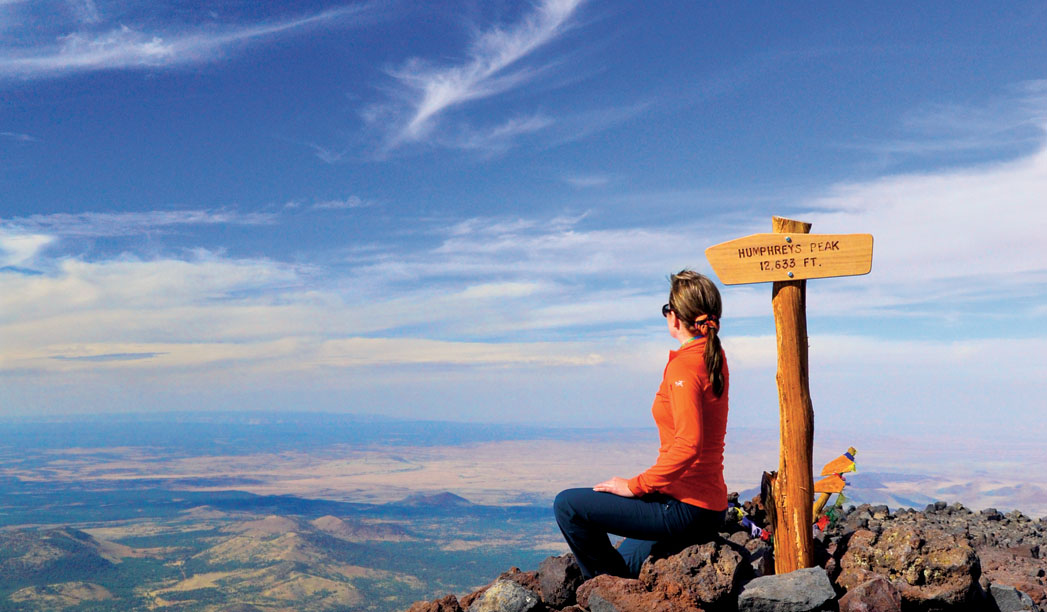
Humphreys Peak captivated us long before we moved to northern Arizona, and judging by the number of people we encountered on our hike to the summit, we aren’t the only ones. Unlike the impressive mountain ranges in California and Colorado, Humphreys is not surrounded by a plethora of peaks. Instead, it rises dramatically above the town of Flagstaff, visible for more than 100 miles in any direction. We’ve seen it snowcapped in the middle of the summer, and we’ve witnessed ethereal clouds seductively caressing the mountain so that the peak is shrouded from sight. Not to put too fine a point on it, but the cliche fits: It’s majestic.
Our decision to summit Humphreys wasn’t planned far in advance, and we didn’t train for six months prior (like we did when hiking to the bottom of the Grand Canyon). We got the itch, picked a date about two weeks out and crossed our fingers that the weather would cooperate. That’s the thing about Arizona’s tallest peak: Conditions are unpredictable. It can snow year-round; in the summer, you have to worry about lightning from monsoon storms. Then there are the temperatures, which can fall below freezing even in August, and the persistent wind. Our crew got lucky and summited on a warmish October day with relatively calm winds and nary a cloud in sight (late spring and early autumn are generally the best months to tackle this trail). Our only complaint was the visibility. Nearby prescribed burns made it hazy.
For all four of us, Humphreys boasted the highest elevation we’d hiked. The trail begins at 9,300 feet and finishes at 12,633 feet. Internet reports said one in four hikers won’t make it to the top, and we all eyed each other surreptitiously, wondering just who would cave. As it turns out (though it might not make for a very exciting story), we all made it to the summit, though some of us were out of breath – and suffering from altitude sickness – more than others. Many hikers choose to turn around at the saddle between Humphreys and Agassiz peaks, which sits at an elevation of 11,800 feet. But that idea didn’t jive with us – it was summit or bust.
Just a little bit of background on Humphreys Peak. It’s one of five mountains that make up the San Francisco Peaks, the remnants of a single volcano that was believed to be upwards of 16,000 feet tall before it pulled a Mount St. Helens and blew its top 200,000 to 400,000 years ago. From tallest to shortest, the range also includes Agassiz, Fremont, Aubineau, Rees and Doyle. According to Brady Smith, public affairs officer for the Coconino National Forest, the Peaks, as locals call the range, have gone through several name changes. In the 1500s, Spanish Conquistadors searching for gold came upon the Peaks and named them “Sierra Sinagua,” which means “mountains without water.” The name didn’t really stick because the Conquistadors quickly left in search of the Grand Canyon and other gold. In 1629, some Franciscan Friars who were doing missionary work in the area named the mountain “San Francisco Peak” in honor of patron St. Francis of Assisi (note that this was more than 100 years before the city of San Francisco in California was founded). On many maps today, the official name is printed as “San Francisco Mountain,” but most people call it “the Peaks” or “San Francisco Peaks.”
G.K. Gilbert gave Humphreys Peak its moniker in 1873. He named the mountain after his superior officer, Brig. Gen. Andrew Atkinson Humphreys, who was a captain with the Ives Expedition in 1851. Humphreys evaluated the survey data of several expeditions that attempted to find routes for wagon roads and a railroad through the region. He later became chief of the Army Corps of Topographical Engineers.
We’ve had quite a few conversations with longtime northern Arizona residents who remember hiking to the summit via the Agassiz Chairlift, which makes the hike much, much shorter. So we asked Brady why that trail is no longer open to hikers.
“In the late 1980s, the Hopi Tribe made a request to Arizona Snowbowl and the [Coconino National] Forest Service to stop allowing people to hike from the top of the chairlift to Humphreys Peak because that took hikers through a most sacred area on the mountain – the living space of the kachinas,” says Brady. “Arizona Snowbowl and the forest service honored that request under a cooperative agreement and placed an officer at the top of the chairlift to keep that from happening. Now it has turned into an interpretive program and people just understand they are not allowed to do that any longer.”